看前须知
关于语言成绩要求:
通常英国院校的雅思成绩要求分为5个等级,标准分别如下:
1级:总分6.5分,每个部分最低6.0分
2级:总分7.0,每个部分至少6.5分
3级:总分7.0分,每个部分至少7.0分
4级:总分7.5分,每个部分至少7.0分
5级:总分8.0,每个部分最低8.0
不同学校、同一学校的不同专业,甚至同一所学校不同类型的硕士对语言要求都有差异,注意仔细查看具体语言要求。
关于学位等级:
英国的高校录取要求分为5个等级,
-
first class degree(一等学位)
-
upper second class degree(2:1学位)
-
lower second class degree(2:2学位)
-
third class degree(三等学位)
-
ordinary degree/pass degree(普通学位)
如果还看不明白,可以参考下面这张图:
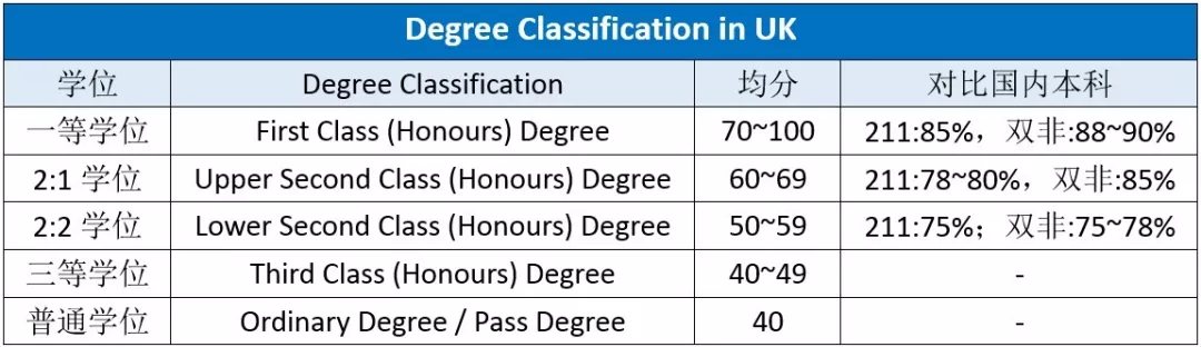
当然每所学校可能会有自己的分类,同学可以参照具体学校的具体专业对号入座,看自己是否符合申请要求。
例如UCL录取大陆高校的学生分为几个不同的等级,UCL认可的list里面包括包括985、211、双一流大学,这些高校标准分为:
Upper second-class (2:1): 最低加权平均分数为85%的学士学位;
Lower second-class (2:2): 最低加权平均分数为80%的学士学位。
非list里面的其他中国大陆学校则要求:
Upper second-class (2:1):学士学位,最低加权平均分数为90%;
Lower second-class (2:2):学士学位,最低加权平均分数为85%。
每个专业的要求不一样,具体专业要求要仔细查看说明。
研究型和授课型:
英国研究生课程分为两种,授课型(PGT:Taught Postgraduate Courses),研究型(PGR:Postgraduate Research Programs)
-
授课型(PGT:Taught Postgraduate Courses):大部分学校学时为一年,少部分学校有两年的课程(谢菲尔德法律专业,爱丁堡建筑专业)。学制分为三个学期,前两个学期以授课为主,第三个学期完成毕业论文。在英国留学的学生90%以上会选择授课式的硕士课程。
-
研究型(PGR:Postgraduate Research Programs):MRes学时为一年,MPhil学时为两年。几乎没有授课内容,以研究课题为主,为继续攻读PHD打下研究基础。
在英国留学的学生90%以上会选择授课式的硕士课程。
1、伦敦大学学院UCL
地区:英国,伦敦
UCL地理相关的学位有很多,其中授课型硕士就包括以下几类:
-
Education(geography)MA
-
Geographysical hazards MSc
-
Geoscience MSc
-
Geoscience (Building Information Modeling and Surveying) MSc
-
Geoscience (Geographic Information Science and Computing) MSc
-
Geospatial Science (Hydrographic surveying)MSc
-
Geospatial Science MSc
-
Social and Geographic Data Science MSc
-
Remote Sensing and Environmental Mapping MSc
研究型硕士包含:
-
Civil Environmental and Geomatic Engineering MPhil/PhD
-
Geography (practice-related) MPhil/PhD
-
Geography MPhil/PhD
-
Human Geography MPhil/PhD
这里重点挑选几个与GIS强关联的授课型硕士专业进行说明,其他专业同学可以登录UCL官网进行查看,这里不作赘述。
Taught degrees | Prospective Students Graduate - UCL – University College London
1)Geoscience (Geographic Information Science and Computing) MSc地球科学(地理信息科学与计算)硕士
简介:
地理空间科学(GIS和计算)硕士课程教授学生处理地理空间数据的理论、工具和技术,从采集到处理再到分析。学生有机会通过研讨会和论文与学者和行业合作伙伴就前沿研究进行接触和合作。
学费和学制:
| 学费 | 学制 | |
| full time | £37,500 | 一年 |
| part time | £18,750 | 两年 |
学历要求:
至少持有英国大学相关学科(如工程、建筑、地理、城市规划、数学、测量、海洋和地球科学、计算机科学)的英国二等(2:1)学士学位,或具有同等标准的海外资格。通常只接受具有一等(first class)或二等(2:1)以上学位的候选人,但也会考虑具有较低二等学位(2:2)并有丰富工作经验的申请人。
语言要求(雅思):
1级:总分6.5分,每个部分最低6.0分
2)Geoscience (Building Information Modeling and Surveying) MSc
地球科学(建筑信息建模与测量)硕士
简介:
专业的建筑信息建模(BIM)课程将教育学生BIM的几何和语义方面,以及地理空间和BIM相关数据的综合管理。这包括测量原理、3D现实捕捉、与测绘科学、地理信息科学和3D几何建模相关的技术概述。
学制和学费:
| 学费 | 学制 | |
| full time | £37,500 | 一年 |
| part time | £18,750 | 两年 |
学历要求:
至少持有英国大学相关学科(如工程、建筑、地理、城市规划、数学、测量、海洋和地球科学、计算机科学)的英国2:1学士学位,或具有同等标准的海外资格。
通常只接受具有一等(first class)或二等(2:1)以上学位的候选人,但也会考虑具有较低二等(2:2)学位并有丰富工作经验的申请人。
语言要求(雅思):
1级:总分6.5分,每个部分最低6.0分
3)Geospatial Sciences MSc地理空间科学理学硕士
简介:
地理空间科学硕士课程向学生传授从采集到处理再到分析的地理空间数据的理论、工具和技术。学生有机会通过研讨会和论文与学者和行业合作伙伴就前沿研究进行接触和合作。
学制和学费:
| 学费 | 学制 | |
| full time | £41,000 | 一年 |
| part time | £20,500 | 两年 |
学历要求:
至少持有英国大学相关学科(如工程、建筑、地理、城市规划、数学、测量、海洋和地球科学、计算机科学)的英国二等学士学位,或具有同等标准的海外资格。
通常只接受具有一等(first class)或二等(2:1)以上学位的候选人,但也会考虑具有较低二等学位(2:2)并有丰富工作经验的申请人。
语言要求(雅思):
1级:总分6.5分,每个部分最低6.0分
4)Geoscience MSc地球科学理学硕士(授课型硕士)
简介:
这个硕士课程是一个独特的广泛而灵活的课程,适合学生的愿望、背景和经验。伦敦大学学院地球科学在地球物理学、地球化学、古生物学、矿物物理学、地球动力学、地质灾害、气候科学、环境地球科学和政策等领域具有优势。学生可以从系内和伦敦大学学院更广泛的可选模块中进行选择,根据自己的兴趣获得硕士学位。
学制和学费:
| 学费 | 学制 | |
| full time | £41,000 | 一年 |
| part time | £20,500 | 两年 |
学历要求:
通常最低要求为英国大学相关学科的二等学士学位或同等标准的海外资格。
如果能够证明有足够的学术背景和适当的现场经验,则可以录取资格低于二等荣誉标准的申请人。
语言要求(雅思):
2级:总分7.0,每个部分至少6.5分。
UCL认可大陆学校名单:
| 北航大学(原北京航空航天大学) | 华北电力大学 |
| 北京外国语大学 | 东北林业大学 |
| 北京林业大学 | 东北师范大学 |
| 北京理工大学 | 东北大学 |
| 北京交通大学(原北方交通大学) | 西北大学 |
| 北京师范大学 | 西北工业大学 |
| 北京化工大学 | 中国海洋大学(青岛) |
| 北京中医药大学 | 北京大学 |
| 北京邮电大学 | 中国人民大学 |
| 中央音乐学院 | 山东大学 |
| 中南大学 | 上海(第二)医科大学 |
| 中央财经大学 | 上海外国语大学 |
| 长安大学 | 上海交通大学 |
| 中国农业大学 | 上海财经大学 |
| 中国药科大学 | 四川大学 |
| 中国地质大学(北京和武汉) | 华南理工大学 |
| 中国矿业大学-徐州/北京 | 东南大学 |
| 中国石油大学(北京和华东校区) | 西南交通大学 |
| 中国政法大学 | 西南大学 |
| 中国科学院 | 西南财经大学 |
| 重庆大学 | 中山大学 |
| 中国传媒大学 | 苏州大学 |
| 大连理工大学 | 天津大学 |
| 东华大学 | 同济大学 |
| 华东师范大学 | 清华大学 |
| 华东理工大学 | 中国电子科技大学 |
| 复旦大学 | 对外经济贸易大学 |
| 哈尔滨工业大学 | 北京科技大学 |
| 合肥工业大学 | 中国科技大学 |
| 河海大学 | 武汉大学 |
| 华中农业大学 | 武汉理工大学 |
| 华中师范大学 | Xi'an Jiaotong University 西安交通大学 |
| 华中科技大学 | 厦门大学 |
| 湖南大学 | 西安电子科技大学 |
| 江南大学 | 燕山大学 |
| 吉林大学 | 云南大学 |
| 兰州大学 | 浙江大学 |
| 中央民族大学 | 浙江工业大学 |
| 南航金城学院(南京航空航天大学独立学院) | 郑州大学 |
| 南京农业大学 | 中南财经政法大学 |
| 南京大学 | |
| 南京理工大学 | |
| 南开大学 | |
| 国防科技大学 |
UCL认可大学名单中的申请人需要满足:
Upper second-class (2:1) :学士学位,最低加权平均分数为85%
Lower second-class (2:2) :学士学位,最低加权平均分数为80%
非认可名单中的申请人需满足:
Upper second-class (2:1) :学士学位,最低加权平均分数为90%。
Lower second-class (2:2) :学士学位,最低加权平均分数为85%。
UCL申请时间:
24年9月申请目前已关闭
25年9月申请尚未开启,根据去年申请时间预计10月中旬开放申请

UCL相关导师:
-
Paul Longley: geographic information science, geo-temporal demographic classifications, micro-demographics of residential and social mobility;
-
Tao Cheng: geocomputation, space-time analytics, big data mining, network complexity;
-
James Haworth: spatio-temporal modeling and analytics, transportation;
-
Adam Dennett: migration modeling, crowd-sourcing GIS, residential mobilities, urban health, beer and brewing geographies;
-
Elsa Arcaute: complexity science, urban systems;
-
Sarah Wise: agent-based model, social media, disaster prevention;
-
Jens Kandt: urban geography, social and spatial health disparities;
-
Neave O’Clery: data and network modeling of economic development and urban systems;
-
Max Nathan: economics of cultural diversity, innovation systems and clusters, public policy for cities (especially policy design and evaluation);
-
Huanfa Chen: spatial optimisation, spatial data science, transportation behaviour modeling;
-
Jonathan Reades: Smart cities and ‘big data’, location and infrastructure networks , new data, open data and ‘old’ methods, housing and socio-economic trends.
利兹大学
University of Leeds
英国,西约克郡,利兹市
GIS相关系所:地理学院
利兹大学地理学院知名校友包括Stan Openshaw, Alan Wilson等GIS及地理学顶级专家学者,亦是geocomputation和Spatial interaction Model 的发源地。
该学院GIS学科提供3-4年制全日制博士项目,以及2年制研究型硕士。此外亦有1年制授课型硕士课程,主要包括 data visualization, geodemographics, retail modeling, environment and remote sensing 等课程。
利兹大学地理所与GIS有关的专业包括:
Environmental Data Science and Analytics MSc(环境数据科学与分析理学硕士)
Geographical Information Science MSc(地理信息科学硕士)
Geographical Information Science MSc (online)(地理信息科学硕士(在线))
Urban Data Science and Analytics MSc(城市数据科学与分析理学硕士)
MA or MSc by Research(研究硕士或理学硕士)
关于认可学校:
利兹大学会对申请人学历进行评估,以确定是否符合要求,地理类可申请的中国大陆地区学校名单如下:
Accepted Chinese institutions for postgraduate admissions | University of Leeds
1)Environmental Data Science and Analytics MSc
环境数据科学与分析理学硕士
专业简介:
我们的地理信息科学硕士专注于GIS的科学、技术和计算方面,特别是社会经济和环境科学。我们将向您介绍GIS以及可用于商业、健康和规划环境的软件包和数据库系统,同时提供可选模块,让您将职业前景扩展到您感兴趣的领域,并了解我们在整个大学进行的世界领先的研究。
申请时间:
30 June 2025
学历要求:
在相关学科(如地理、地球或环境科学、经济学或社会科学、数学、计算机科学或其他可以证明良好算术和/或计算技能的学科)获得2:1(荣誉)的学士学位。
符合以下任一条件的申请人将根据具体情况予以考虑:
相关工作经验和专业培训课程受到积极评价,特别是对于一级学位低于正常最低要求的候选人。
学制:
12 months full time
24 months part time
语言要求:
雅思总分6.5,任何部分不低于6.0
费用:
国际学生费用是30750英镑
课程内容:
必修:
Professional and Personal Development
GIS Data Visualisation and Analysis
Dissertation (GIScience)
选修:
GIS and Environment
Geodemographics and Neighbourhood Analysis
Digital Image Processing for Environmental Remote Sensing
Environmental Assessment
Web-Based GIS
Predictive Analytics
Programming for Geographical Information Analysis
Big Data and Consumer Analytics
2)Geographical Information Science MSc (online)
地理信息科学硕士(远程)
课程简介:
本课程的主要是提供一个在线学习机会。
课程将提供核心GIScience技能培训,然后是选修一系列当代领域的专业技能发展,并有机会在研究负责人的指导下进行一项独立的原创GIScience研究。
该课程提供跨越人文/自然地理和技术技能的专业分析模块的选择。
相关导师:
-
Alison Heppenstall: geocomputation, machine learning, geospatial AI, agent-based modeling, smart cities;
-
Andy Newing: retail analytics, retail location planning, spatial analysis, service analysis, geodemographics, accessibility;
-
Ed Manley: urban data science, agent-based modeling, spatial cognition, travel and mobility, data visualization;
-
Graham Clarke: geodemographics, public health, retail, urban simulation, accessibility;
-
Lex Comber: spatial analysis, geocomputation, land cover / land use, spatial data quality, spatial planning, uncertainty, evidence combination, search heuristics, location-allocation;
-
Mark Birkin: spatial analysis and policy, demography, social simulation, retail, public health, microsimulation, agent-based modeling;
-
Nick Malleson: agent-based modeling, crime modeling, city simulation;
-
Nik Lomax: demography, population projection, microsimulation, internal migration, international migration, consumer demand modeling;
-
Steve Carver: wilderness, wildland, rewilding, landscape evaluation, GIS, spatial analysis, environmental modeling, participatory GIS.
南安普顿大学
University of Southampton
英国,汉普郡,南安普顿市
GIS相关系所:地理与环境系
南安普顿大学的地理与环境学院历史悠久,是英国地理和环境科学研究顶级中心之一。研究生课程设置应用地理信息系统与遥感专业,是英国少数研究生课程中侧重于遥感应用以及与环境研究相结合的大学院校。 地理与环境科学学院的研究立足于解决当今一些主要的全球挑战,包括气候变化,社会和健康不平等,可持续发展;保护生物多样性;贫穷和衰退。主要分为以下研究小组:地球表面动力学(ESD);环境科学中心 ; 经济,社会与治理;GeoData (进行应用环境研究);全球环境变化和地球观测(GECEO); 南安普敦大学(PLUS)的古环境实验室;人口,健康与福祉(PHeW)
英国的研究生项目主要多为授课制项目,南安普顿的应用GIS&RS项目的学制为一年三个学期,第三个学期用于完成毕业论文。该项目提供较多的选修模块,从python开发、遥感、卫生健康到环境应用。每年会改进和新增不同的选修以满足研究生的研究兴趣点。申请一般会卡80均分左右的GPA,会要求地理学、物理学、地理信息学、环境科学、生态学、生物学、地质学和社科背景。如果有相关工作经验,学校会降低均分要求。 博士学制为3-4年,一般会有两到三位导师负责博士生的研究学习工作,会在building 44拥有一间自己的办公位。
相关导师(招生界面):
-
Patrick Osborne: urban remote sensing, machine learning in remote sensing, urban stressor etc;
-
Tony Brown: floodplain geomorphology and palaeohydrology, alluvial geoarchaeology, mediterranean and semi-arid alluviation and environmental history, human-environment relationships and theory, forensic palynology;
-
Nick Clarke: urban geography, cultural geography, political geography, qualitative methods. Specific topics: migration, tourism, consumption, ethics, social movements, urban policy, urban politics, local government, localism, political participation;
-
Samantha Cockings: automated zone design, spatio-temporal representations of population, geographies of health & health care, socio-economic applications of GIS;
-
Gareth Roberts: monitoring land surface dynamics, fire in the natural environment;
-
Steve Darby: fluvial geomorphology, process sedimentology;
-
John Dearing: global environmental change, ecosystem services, social-ecological system dynamics, paleoenvironmental reconstruction, human-environment interactions, poverty alleviation;
-
Mary Edwards: environmental change over decades to millennia;
-
Jane Hart: glaciers and climate change, environment sensor networks, quaternary glacial sedimentology;
-
Brian J. Hracs: economic geography, creative economy, urban geography qualitative methods;
-
Paul Hughes: holocene peatland development, recent degradation of fen and lowland bogs in Britain and Northwest Europe;
-
Pete Langdon: climate change, past & future, environmental change, palaeolimnology, eutrophication, chironomids, lakes, palaeoecology & geochronology;
-
Julian Leyland: landscape evolution modeling, fluvial geomorphology, terrestrial laser scanning;
-
Dave Martin: population geography, geographical information science, geography of health, quantitative secondary data analysis;
-
Jo Nield: modeling of aeolian landscapes and processes, terrestrial laser scanning applications in aeolian process dominated environments;
-
Booker Ogutu: remote sensing of terrestrial ecosystems, land cover and land use change, impacts of climate change on terrestrial ecosystems;
-
Suzanne Reimer: economic geography, feminist geography, cultural economy.
曼彻斯特大学
The University of Manchester (UoM)
英国,曼彻斯特市
GIS相关系所:环境,教育与发展学院
地信专业侧重地理信息系统和遥感方面的理论、软件知识学习,在各种专业领域的空间数据分析,以及在GIS项目中的广泛应用。
硕士项目 MSc Data Science (Applied Urban Analytics)
相关导师:
-
Jonny Huck: mathematical geography, cartography, geography (General);
-
Claire Goulsbra: the hydrology and geomorphology of the South Pennine peatlands, carbon losses from eroding peatland systems;
-
Angela Harris: remote sensing, ecology, Peatlands, vegetation;
-
Sarah Lindley: geography’s environmental processes, urban and regional ecology.
格拉斯哥大学
University of Glasgow (GLA)
英国,苏格兰,格拉斯哥
GIS相关系所:地理与地球科学学院,城市研究系,城市大数据中心
格拉斯哥大学在与城市研究和大数据相关的地质学、地理学、测绘学、环境科学、社会科学、公共卫生等学科领域有着很强的研究实力和学术传统。urban studies系主要包括city planning, housing studies, real estate, public and urban policy, urban transport, urban analytics等硕士专业,以及urban studies的博士点。
相关导师:
-
Nick Bailey: housing and neighborhood, administrative big data;
-
David McArthur: transportation, econometrics;
-
Jinhyun Hong: transportation planning, active travel;
-
Qunshan Zhao: GIScience, remote sensing, spatial analysis, location modeling and analysis, urban analytics, urban data science;
-
Jing Yao: Geographical Information Science, Spatial Statistics, Spatial Optimization, Location Modeling, Health Geography, Regional Science, Urban and Regional Planning and development;
-
Brian Barrett: remote sensing, terrestrial environment;
-
Ana Basiri: geospatial data science, navigation, GPS;
-
David Forrest: cartography, GIS.
爱丁堡大学
The University of Edinburgh
英国,苏格兰,爱丁堡
GIS相关系所:地理科学学院
爱丁堡大学地理科学学院建院于2002年,方向偏开发。
地信学院下包含多个GIS相关项目,提供两种硕士项目Msc by Research(即研究型科学硕士)、Msc by Taught(即授课型科学硕士)和相关博士项目。
Msc by Research:主研究,申请时需要提交不超过两页的研究计划。
-
Palaeontology and Geobiology ;
-
Human Geography ;
-
GeoSciences Individual Project .
Msc by Taught:
-
Geographical Information Science ;
-
Earth Observation and geoinformation management ;
-
Environment and Development ;
-
Marine Systems and Policies ;
-
Soils and sustainability .
学院相关项目众多,还有几个硕士项目和online master项目,可以在School of Geosciences: Taught Masters Programmes自行查阅
Msc of GIS不严格卡本科相关专业背景。其中GIS硕士项目必修课程包括research practice and project planning, dissertation in GIS, spatial modeling and analysis, technological infrastructures for GIS;其他选修课程内容可在此查询。
相关导师 :
-
Neil Stuart: hydrology;
-
Bruce Gittings: web-based geo-information;
-
William Mackaness: UGC, VGI;
-
Zhiqiang Feng: health geography, population geography, spatial analysis.
纽卡斯尔大学
Newcastle University 英国,纽卡斯尔市
GIS相关系所:测绘工程系, 地理系
纽卡斯尔大学的测绘工程系历史悠久,在大地测量,遥感,以及空间分析等方面实力极为强劲, 全英国排名第二, Stan Openshaw、David Parker曾在此任教。该系GIS本科毕业申请可修1年硕士+3年博士 (Centre for Doctor Training, 全奖并且对国际学生开放, 系主页地址。硕士毕业申请可修3年博士。其GIS项目主要包含geospatial data analysis, remote sensing, geovisualization, smart cities 等课程。
相关导师:
-
Jon Mills: 3D Modelling, LiDAR, geospatial analytics, geovisualization;
-
Jeremy Crampton: geolocation technologies, urban GIS, spatial big data and decision-making, geosurveillance and privacy;
-
Phil James: smart cities, urban data analytics, geospatial database systems, geovisualization;
-
Jin Xing: CyberGIS, smart cities, remote sensing, GeoAI, autonomous vehicles.
-
Wen Xiao: transport systems and vehicles, infrastructure and urban systems, built environment and environmental informatics, hazard monitoring and impact analysis.
纽卡斯尔大学地理系始建于1927年, 在自然地理和人文地理方面都享有盛名。该系GIS本科毕业申请可修1年硕士+3年博士,硕士毕业申请可修3年博士。其GIS项目主要包含Human GIS, Urban GIS, 以及Political GIS等课程。
-
Rachel Franklin: social GIS, demography, geographical analysis;
-
Wen Lin: urban GIS, digital humanity, political GIS.
谢菲尔德大学
The University of Sheffield
英国,谢菲尔德
GIS相关系所:地理系
谢菲尔德大学应用地理信息系统理学硕士项目由城市研究与规划系和地理系联合办学,授课型硕士全日制一年。在谢菲尔德大学GIS硕士项目学习期间,学生将掌握在地理信息系统、应用政策研究、全球问题空间数据分析领域工作所需的技术技能、实践经验和理论知识,深入学习高级空间分析、地理可视化、实践中的地理信息系统政策应用、专题制图和图表创建等。
相关导师:
-
Rowland Atkinson: urban and housing studies, sociology, geography and criminology;
-
Chris Clark: glacial geomorphology and glaciology, and on GIS;
-
Simon Marvin: systemic transitions, climate change, ecological security and smart cities;
-
Andrew McGonigle: volcano remote sensing, volcano atmosphere interactions, other environmental sensing;
-
Stephen Livingstone: surface meltwater.
伦敦国王学院
King’s College London (KCL)
英国,大伦敦地区,伦敦
GIS相关系所:地理系 伦敦城市科学与进步中心
伦敦国王学院有关GIS的研究分别在地理系和与华威合办的伦敦城市科学与进步中心(CUSP-London)中有所涉及。前者侧重传统地理学的应用,后者强调城市数据在城市中带来的影响。该校GIS有两个项目,分别是各自下设在地理系和CUSP-London的1年制授课制硕士,以及地理系传统学术型的项目:本科毕业申请可修2年mphil,硕士毕业申请可修3年phd。
硕士项目 Urban Informatics MSc
相关导师:
-
Chen Zhong: Urban mobility, Transport geography, Spatial analysis and modelling, Geo-visualisation, Urban planning and transport planning;
-
James Millington: Wildfire-Environment-Society interactions, Agent-based modelling of geographical systems, Spatial modelling of ecological succession-disturbance dynamics;
-
Narushige Shiode: Spatial analysis and modelling, GIS science and geo-visualisation, Urban and regional analysis, Big and open data and neo-geography;
-
Zahratu Shabrina: the possible disruptions from the rapid adaptation of digital platforms in cities using various Spatial analysis methods and predictive modelling;
-
Terence Dawson: Complex systems and Earth systems science, Biogeography, evaluating environmental change and anthropogenic impacts on landscapes, biodiversity, natural resources, food security and ecosystem services, development of Remote Sensing, Geographic Information System (GIS) and modelling tools for studying and understanding biodiversity, sustainability development and the interaction between climate change and social-ecological systems;
-
Mark Mulligan: development and application of spatial policy support systems, agriculture, land use change and climate change impacts on water and ecosystems, ecosystem services mapping and modelling, tropical forests and tropical montane cloud forests, Environmental modelling, environmental Geographical Information Systems (GIS) and environmental monitoring with open source hardware;
-
Rita Borgo: Data Science, Data Visualisation, Visual Analytics, Human Factors in Visualisation, Urban Informatics, High Performance Computing;
-
Daniele Quercia: Urbanism, Computational Social Science, HCI, Data Mining;
-
Yijing Li: spatial analysis in urban crime, counter terrorism strategies based on empirical studies, climate change influences on crimes, and risk management strategies upon social media data analysis.
伯明翰大学
University of Birmingham (UoB)
英国,西米德兰郡,伯明翰市
GIS相关系所:地理、地球与环境科学学院
伯明翰大学的地理研究主要集中在人文地理、河流环境及管理、大气污染等。硕士项目中会对GIS有所涉及,但无具体的项目。该系项目如下:本科毕业申请可修1年授课制硕士或2年研究型硕士,硕士毕业申请可修3年博士。
相关导师:
-
Emma Ferranti: the impact of weather on infrastructure, green infrastructure, Air Quality, and GIS;
-
Zhaoya Gong: leveraging computational and Data Sciences to advance GIS, dynamic processes of urbanisation and complex modalities of Spatial Structures generated at various scales.
兰卡斯特大学
Lancaster University (LU)
英国,兰开夏郡,兰卡斯特市
GIS相关系所:地理学院
兰卡斯特大学的地理研究历史悠久,下设8个研究方向。该校对GIS的研究主要侧重Geospatial Data Science,Peter Atkinson在此任教。硕士项目中会对GIS有所涉及,但无具体的项目。该系项目如下:本科毕业申请可修1年授课制硕士或2年研究型硕士,硕士毕业申请可修3年博士。
相关导师:
-
Peter Atkinson: Spatial and space-time sampling effects, Disease transmission systems, especially vector-borne systems, global vegetation and land cover changes, natural hazard impacts and risks;
-
Alan Blackburn: Remote sensing of plant responses to environmental stress, modelling the relationships between spatial properties and ecosystem processes, applying geospatial technologies across different environmental systems;
-
Amber Leeson: ice-climate interactions, Remote Sensing data, GIS and Data Science techniques;
-
Duncan Whyatt: GIS, coastal management, urban development, landscape ecology, renewable energy and mapping trends in social media;
-
Ce Zhang: Artificial Intelligence and Machine Learning (Deep Learning), Geospatial Data Mining and Modelling (Geospatial Data Science), Landscape Pattern Analysis (Vector-based and Raster-based GIS), Remotely Sensed Image Analysis and their Applications.
利物浦大学
University of Liverpool (UOL)
英国,默西赛德郡,利物浦市
GIS相关系所:地理与规划系
利物浦大学地理与规划系下设四个研究方向:环境变化、地理数据科学、权力,空间与文化变革、规划,环境评估与管理。该系对GIS的研究主要分布在Geographic Data Science。硕士项目中有专门的针对地理数据科学的1年授课制项目。该系项目如下:本科毕业申请可修1年授课制硕士或2年研究型硕士,硕士毕业申请可修3年博士。
硕士项目 Liverpool Geodata Science MSc
相关导师:
-
Dani Arribas-Bel: cities, Spatial Analysis, statistics, open source computing, new forms of data;
-
Les Dolega: retail, resilience, regional studies, GIS, urban systems;
-
Mark Green: health-related behaviours, classifications, Spatial statistics;
-
Alex Singleton: Geodemographics, urban systems, Data Science, mobilities / transport.
诺丁汉大学
University of Nottingham (UoN)
英国,诺丁汉郡,诺丁汉市
GIS相关系所:地理学院
诺丁汉大学的地理学院涉猎领域广泛,在各个领域都提供授课。硕士项目中会对GIS有所涉及,但无具体的项目。该系项目如下:本科毕业申请可修1年授课制硕士或2年研究型硕士,硕士毕业申请可修3年博士。
相关导师:
-
Matthew Smallman-Raynor: spatial dynamics of infectious diseases, historical geography of war epidemics, geography of HIV infection and disease Island epidemics;
-
Doreen Boyd: Remote Sensing, land system, tropical rainforests, temperate peatlands, boreal forests and mountains;
-
Giles Foody: VGI, land cover changes on the carbon cycle and patterns of biodiversity, machine learning methods for image analysis;
-
Franziska Schrodt: plant functional traits, macroecology, species distribution modeling, ecosystem functioning, global change, Remote Sensing of Vegetation, Machine Learning, Bayesian Statistics.
GIS资料分享![]() https://www.wjx.cn/vm/OaQEBVS.aspx#
https://www.wjx.cn/vm/OaQEBVS.aspx#


![[linux 驱动]块设备驱动详解与实战](https://img-blog.csdnimg.cn/img_convert/31f10b273e742e762b318525eeb492b8.png)